Lesson Plan
Background Information
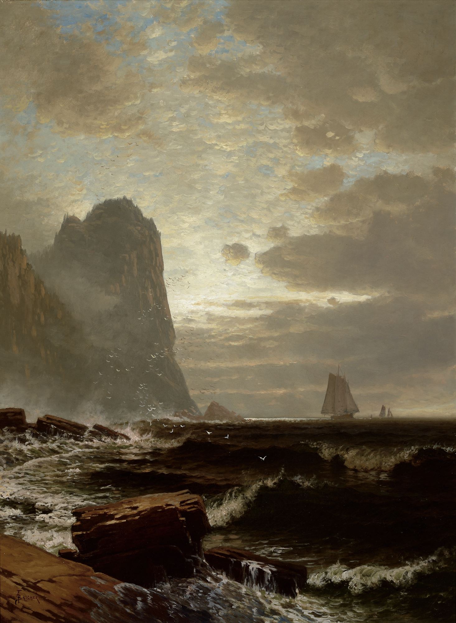
Grand Manan is an island in the Grand Manan Archipelago in the Atlantic ocean off the coast of Canada – it is located in the Bay of Fundy. The western side has three-hundred-foot cliffs and high winds (and wind power ventures), so most residents live on the eastern side of the island, and the area has some of the strongest tides in the world. (Source: http://en.wikipedia.org/wiki/Grand_Manan_Island)
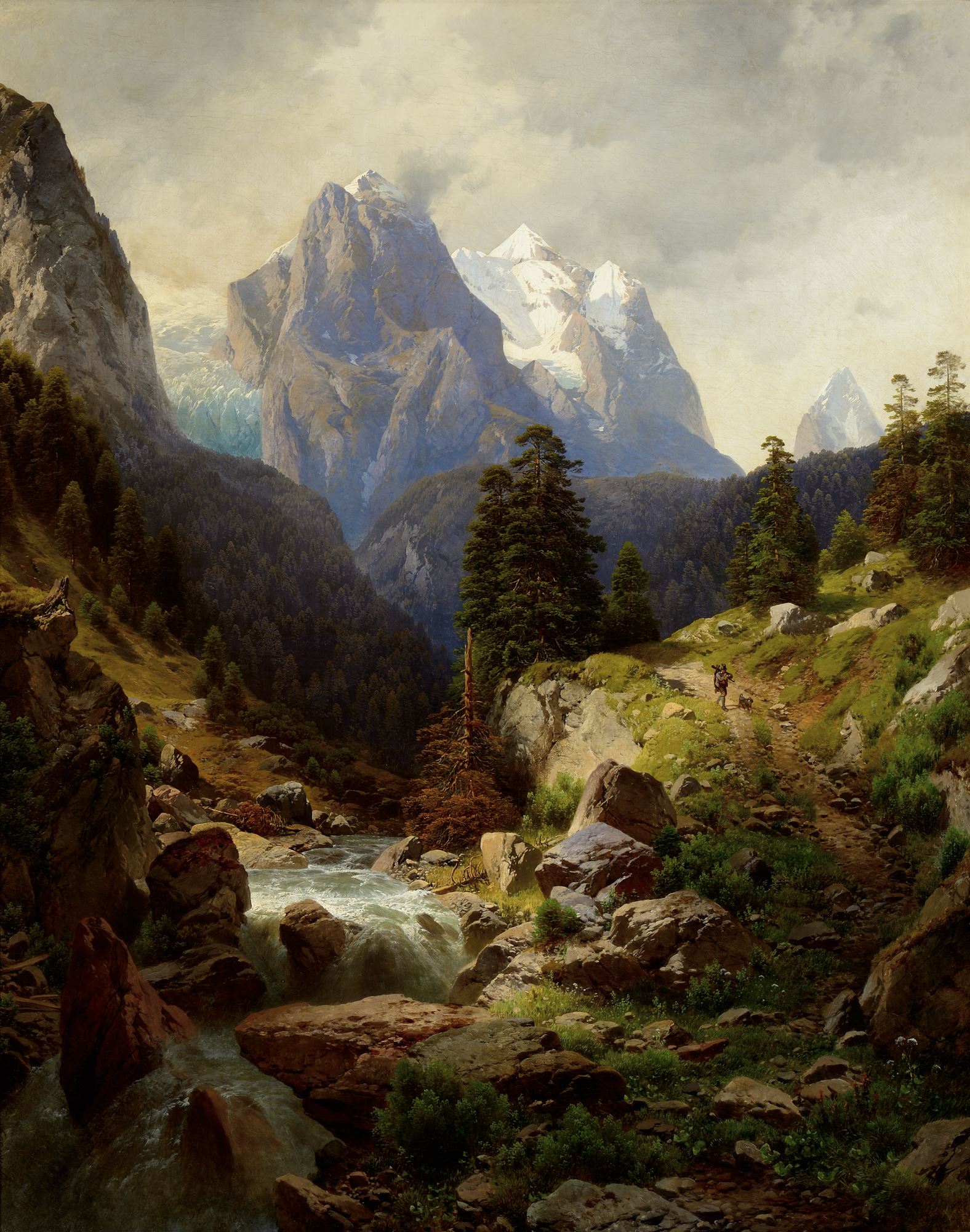
The Alps are one of the great mountain range systems of Europe, stretching approximately 1,120 km (700 miles) across seven countries from Austria and Slovenia in the east through Switzerland, Liechtenstein, Germany, France to the west and Italy and Monaco to the south. The Alps were formed over millions of years when the African and Eurasian tectonic plates collided, causing extreme compression of marine sedimentation to rise and fold into high mountain peaks such as Mont Blanc and the Matterhorn. Mont Blanc, spanning the French–Italian border, is the highest mountain in the Alps, at 4,810.45 m (15,782 ft). The area is home to many peaks higher than 4,000 m (13,123 ft), called the “four-thousanders”. The altitude and size of the range affects the climate in Europe; in the mountains precipitation levels vary greatly and climactic conditions consist of distinct zones.
The Alps are a classic example of what happens when a temperate area at lower altitude gives way to higher-elevation terrain. Elevations around the world that have cold climates similar to those of the polar regions have been called Alpine. A rise from sea level into the upper regions of the atmosphere causes the temperature to decrease. The effect of mountain chains on prevailing winds is to carry warm air belonging to the lower region into an upper zone, where it expands in volume at the cost of a proportionate loss of heat, often accompanied by precipitation in the form of snow or rain. The height of the Alps is sufficient to divide the weather patterns in Europe into a wet north and a dry south because moisture is sucked from the air as it flows over the high peaks. (Source: http://en.wikipedia.org/wiki/Alps)
Day 1
Direct Instruction
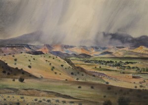
Show the artwork Hunting in the Alps, by Adalbert Waagen. For the artwork, ask students:
- What’s going on in this artwork?
- What do you see that makes you say that?
- What more can we find?
- Tell me about the character/characters in the painting.
- What details do you see that make you say that.
- Describe the setting in the painting.
Day 2
Look at Hunting in the Alps, by Adalbert Waagen. Discuss:
- How does the weather affect the land features?
- What will happen thousands of years in the future?
- How will the land be changed?
- What do you think this mountain area looked like thousands of years ago? What makes you say that?
- Why?
- What are natural resources?
- What are some of the natural resources people could use in this setting?
- How would they use them? How would people bring them to villages or cities?
- What are the positives and negatives consequences of people using resources in the setting of this painting?
Students draw and write about the positive and negative uses and responsible management of natural resources. (Template attached.)
Day 3
Show the artwork At the South Head, Grand Manan, by Alfred Thompson Bricher. For the artwork, ask students:
- What’s going on in this artwork?
- What do you see that makes you say that?
- What more can we find?
- Tell me if you see any people or animals in the painting.
- What details do you see that make you say that.
- Describe the setting in the painting.
Class discussion:
- How does the weather affect the land features?
- How will the land be changed?
- What makes you say that?
- Why?
- What are natural resources?
- What are some of the natural resources people could use in this setting?
- How would they use them? How would people bring them to villages or cities?
- What are the positives and negatives consequences of people using resources in the setting of this painting?
Compare and Contrast Venn diagram: Students compare and contrast both paintings considering weather, landforms, maps, resources (template attached).
Day 4
Weather and water cycle. “Look at the two paintings. What evidence of evaporation, condensation, precipitation and collection the water cycle do you see in these paintings? How do the settings (e.g., elevation, location) influence the type of weather (e.g., temperature, precipitation, and water cycle) elements that you see?”
Day 5
Map work using directional words. (If desired, teacher can implement specific map curriculum first, before teaching this lesson, including how to read items on grids, and map symbols/keys.)
Look at Hunting in the Alps, by Adalbert Waagen.
Teacher provides compass rose labels (using index cards or other means) north, south, east and west and label the art. Can also have students stand up and pat their head for north, right hand for east, stamp feet for south and wave left hand for west. Try pairing movements with “Never Eat Soggy Waffles”.
Guided Practice
Teacher models using grid, mapping classroom or use other painting (Grand Manan) and show how to create map coordinates on a grid.
Students: Using a grid, use coordinates and draw where the mountain, glacier, stream and other features would appear on your grid map. Add symbols and map key. (Template for grid paper attached)
Day 6
Map making. Look at At the South Head, Grand Manan, by Alfred Thompson Bricher.
Independent work
Students will make a map showing where the island, cliff, bay and ocean could be located. Show where towns and other human construction could exist, label landform features, compass rose, use symbols and make map key. Teacher shows how to use rubric for student and teacher assessment. (Grid template and map rubric attached) Teacher may want students create a realistic map, or use an actual map of Manan island from: wikipedia.org/wiki/Grand_Manan_Island.)